Literally means “Ali’s mother”, but it is actually an Egyptian bread and butter pudding.
Umm Ali - an Egyptian bread and butter pudding (Source: stolen from desertcandy.blogspot.com)
According to folklore, the pudding was invented when a ravenous sultan on a hunting trip passed through a small village in search of food. The best cook in the village (named Umm’Ali), eager to please this important visitor, combined the only ingredients she had around-some stale pastry, nuts, and coconut. She covered it with sugar and baked it in the oven. The sultan loved the dessert, and a tradition was born. (Source: oattravel.com)
I fall in love with this desert the first time this delicious bread and butter pudding pass through taste sensors on my tounge. Since then it becomes one of my favorite Arabian dessert. Couple times I tried myself cooking and preparing Umm Ali, and can’t stop trying. Fortunately, Umm Ali is regularly served in Qatargas canteen during lunch time. So I can enjoy my favorite without any hassles of cooking.
Preparation and cooking steps are straight forward and easy to follow and complete by even the beginner.
Prep Time: 15 minutes
Cook Time: 30 minutes
Ingredients:
1 package of frozen puff pastry (17 ounces)
1 15 oz can of sweetened condensed milk
3 cups water
1/2 cup cream
3/4 cup pistachios, shelled, chopped
1/2 cup pine nuts
1/2 cup almonds
1/2 – 3/4 cups coconut flakes (depending on taste)
1/2 teaspoon vanilla extract
Preparation:
Preheat oven to 425 F. Unroll puff pastry sheets and place on greased baking sheets. Bake for 15 minutes. You want the puff pastry to be golden and puffed. Remove from oven. Do not turn oven off; you will be using it in a few minutes with the same temp.
Break puff pastry into small pieces (about 1-2 inches. Add nuts and coconut and be sure that they are mixed well and evenly distributed. Place nuts and bread in greased 9×12 baking dish.
In a saucepan, heat sweetened milk, vanilla, and water on medium heat. Allow to cook for about 3-5 minutes. Remove from heat then allow to cool.
Pour milk over puff pastry/nut mixture. Pour creme on top and bake uncovered for 15 minutes.
Date Palm with young fruits (photo taken at Al Waha Club, Al Khor Community, June 2009)
Date Palm Facts:
– There are 13 species of date palms
– Iraq is the biggest producer of date palm in the world
– This palm is only very happy in dry atmosphere, and it does not do well in high humidity
– Date palms can take 4 to 7 years after planting before they will bear fruit, and produce viable yields for commercial harvest between 7 to 10 years
– Mature date palms can produce 80–120 kilograms (176–264 lbs) of dates per harvest season
– Dates are believed to have originated around the Persian Gulf, and have been cultivated since ancient times from Mesopotamia to prehistoric Egypt, possibly as early as 4000 B.C
Musfer Sinkhole is the official name of a karst cave in Umm Al Shabrum, central Qatar. This sinkhole is one of the karst features. Other karst features include depressions, caves, and solution hollows. Karst is a distinctive environment characterized by landforms that are the product of dissolution of surface and subsurface rock by natural water to a greater extent than in other landscapes. It occurs both as surface and underground features. Several substantial caves are known in Qatar, but many have probably been filled with blown sand, or have collapsed to produce some of the thousands of depressions or dolines.[1]
Musfer Sinkhole
Karst in Qatar occurs as three types: sinkholes, simple depressions, and compound depressions. Simple depressions are those with a single center. Compound depressions have more than one center, and are large and rectangular or irregular in shape. These depressions seem to have formed through the amalgamation of several simple depressions. More than 9700 large and small depressions, and several exposed sinkholes and caves are known.[1]
Sinkholes are concentrated in the central and northern parts of Qatar. Musfer sinkhole large karst collapse feature is expressed by a 1.5 by 0.5 km surface depression up to 20m deep. It has an opening of 12 x 4.5 m and is at least 100 m deep, though filled with sloping loose sand at the bottom. Gypsum layers of the Lower Dammam Unit and the Rus Formation occur at the bottom of this sinkhole. The cave walls are composed of the upper Dammam dolomite & limestone unit and the lower Dammam laminated shaly & silty unit. It is suspected that this sinkhole is part of a much larger cave system. [1]
Area near Musfer SinkholeInside Musfer Sinkhole
How it is formed [2]
Downward percolating rain water dissolves carbonate rock and causes collapse of the overlying rock. Large depressions (sink holes) and caves form over fracture or fault zones which drains the water away. In humid climates this process forms a typical karst landscape with frequent large sinkholes often filled with water in a subterranial drainage system. Initial dissolution took place in the Pliocene when the climate changed to more humid and sea level rise caused high ground water levels. The karst features were caused by the dissolution of Rus Formation gypsum beds during humid and wet periods in the Pliocene and Pleistocene (Hofuf Formation deposited in Pliocene)
The caves and sinkholes of Qatar is thought to have been formed in the Mid Pleistocene (325,000-560,000 years ago) when the climate was humid.
Directions: [Note: from personal experiences]
We left Doha (to be exact Villagio Carrefour parking lot) around 05.17 AM, heading for Salwa Road. About 19.4 km from Salwa Interchange, we turn right to road leading to Umm Ash Shubrum. Approaching this turn off, you will see the Earth Satellite Tracking Station. The cave is to the right near the station. Entering turn off, you will have intersection. Both left and right turns can lead you to the cave. We chose turning left which seemed a good decision as the road is new and in good condition. (later when heading back to Doha from cave we come to know that we could have turned right for easy navigation although road was not as good as the left option; if you take the turn-right then left option you will see camel farm at the road intersection after about 4km). About 600m from the intersection we took right turn to another asphalt road. We drove around 4.1 km before making right turn at the road intersection. We turned right to asphalt road with full of potholes that we opted to drive alongside the road on dirt track. Driving about 700m from intersection, we made a left turn to not-so-obvious dirt track leading to the cave. The cave is located on an area with scattered scrubs after the power line. So make sure that you are crossing underneath power line. It took us nearly 850 meters from thepotholed asphalt road to the cave.
There is nearby sinkhole (called Mudlem Sinkhole or Dark Cave), near Earth Satellite Station, which is ~150 m deep, filled with sloping loose sand and brackish water at the bottom. The hole has an opening of 15 m in diameter. The entrance, however, had been closed.
For safety reasons, Musfer Sinkhole is chain-link fenced; Normally closed (but not locked) a small gate is provided for access. As you start going downward the cave, you will feel temperature start decreasing and humidity increasing. No particular pathway to go to the bottom of cave; just step on stones. What interesting is that we can see layers of formation at the cave wall, and find trail of motorcycle tire (yes, motorcycle tire trace), track of bettle route (or may be small snake, I don’t know), feces of animal, and cuspid. There is a dark small gap at the bottom but we did not have courage to pass through it…..is it linked to a bigger cave system?
See the layers of formation (and Arabic graffiti?)
Track of beetle or snake?
Coordinates:
Turn-off Umm Ash Shubrum 25 8’14”N 51 13’47”E
Musfer Sinkhole 25 10’30”N 51 12’41”E
GPS screen shot shows trip data from Villagio to Musfer Sinkhole
Sources:
“MIDDLE PLEISTOCENE KARST EVOLUTION IN THE STATE OF QATAR, ARABIAN GULF” ABDULALI M. SADIQ AND SOBHI J. NASIR (Department of Geology, The University of Qatar)
Revisited the island on the 22nd of Dec 2012. See full post and pictures here
Crossing the breach
Crossing the breach
Mangrove in the island
Halopeplis perfoliata
UPDATE:
I visited the island on 28 Nov 2012 very briefly for the purpose of preliminary survey for the trip I plan for a larger group later in Dec. The island doesn’t change much. The breaches are still there; mangrove still grows. Disappointingly, rubbish starts visually discomfort the visit. The island has become popular and irresponsible people littered the island. Please if you visit the island, leave no trace behind except your footprints! I beg you
From this last visit I attach some pictures to complement this post. Enjoy the island.
—-
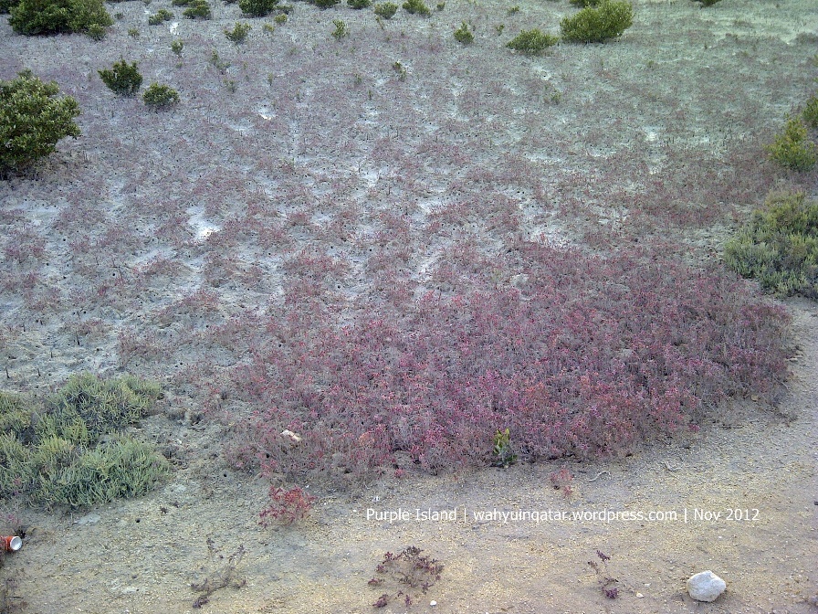
Purple Island, a.k.a. Al Khor Island or Jazirat Al Ghanim is situated in Al Khor, some 40 km from West Bay, Doha. This small fish-shaped island is linked to the mainland by an earthen walkway which had been breached in two places to allow tidal access to the green salt-encrusted mangrove forest which encircle the walkway and island.
Aerial Photo of Al Khor Island (Source: QNHG website)
Despite small (measuring only 600mx400m), the island features uncommon and interesting vegetation and the mangrove forests are home to fish, crabs, shellfish and a wide variety of birds. The Qatargas-sponsored Qatar Archeology Project in 2000 (source: Qatargas.com) confirms intermittent human settlements on the island during the last 4000 years. The results of the project throw light on Qatar’s role in the network of ancient and more recent maritime trade routes. They have also enabled the archeologists to typify the nature of coastal settlements in the region. These excavations were the first on the island since the early 1980s, when a French Archeological Mission uncovered evidence of a thriving dye-production center there, 1400-1200 BC.
During the Bronze Age (2000 -1000 BC), parts of the Al Khor Island were used as temporary campsites. During these latter excavations, five types of structures were revealed. They consisted of rectangular as well as circular stone-lined fire pits, small un-lined hearths, large circular stone-lined structures and post settings consisting of small pits. All of them were constructed on or dug into the beach surface. They were widely scattered, indicating an extensive, rather than a concentrated occupation of the area. Many of the fire-pits have been in use during various periods from the Bronze Age until present day.
During the Islamic Period (900-1400 AD), the island continued to be involved in trade. In addition, fishing and pearling were major local activities. Unlike earlier and later centuries, artifacts from this period are rare, and this is one reason why the team was excited about what they uncovered.
The various ceramics found during the excavations were dated by comparing them to the reference material in the Qatar National Museum. They included Barbar ware, Kassite, Sasanian and various Late Islamic pottery, among the latter, the well-known “Julfar ware” from the Northern United Emirates from the 14th century and onwards.
My family visited this island on Friday early morning, 12 June 2009. When we were there, one woman with her dog seen morning walked around the island. Access to the island is quite easy – see directions below. No 4WD vehicle required as the road is firm sand, probably because it’s compacted by heavy equipment commuting from/to sand processing plant. We have to park at the edge of causeway. It’s no way that vehicle can enter the island although we saw tire tracks on the causeway.
Park your car at the start of causewayFew meters into start of causewayThe first breachWading through tidal access on the causewayThe second breach
It’s about 480m of causeway linking the island to mainland. Two broken tidal access with water depth ranging from ankle-deep to about below the knees, and four dry gaps make walking through causeway an enjoyable experience. Crossing the tidal accesses, you might be scared by a colony of small crabs sunbathing on stepping stone or diving in clear slow current flowing water. It’s also quite interesting to see new mangrove trees jutted out of mud, sometimes become a playground for crabs.
Tree climb crab race (panjat pinang ala kepiting, Ind.)
Mangrove forest is one of the points of interest on the island; however, you might find yourself surprised by the fact that there are so much shells scattered even in the middle of island where low and high tide seawater seems couldn’t reach. In one spot on the west side, there is a mound of shell bunched at the beach. You might also find a fossil-like object that weather and time has made to the shells.
Salt-encrusted mangrove forestMangroveAl Kheriza? (beach plant)Dry breachA fossil-like object that weather and time has made to seasnail shellsDon’t know how this fish casted awayAre these dye-producing seasnails?Hills on the islandRock formation on the islandLooking right from the hilltopOn the Purple Island beach….Sunset with Al Khor corniche/town as a background
Purple Island is not a flat sand island; there are several low limestone cliffs throughout the islands, noticed as a dark portion in the pictures above.
Purple Island owed its name from the ancient purple dye producing site that was situated on the island, dated back 3,400 years ago. The purple dye was produced from a species of sea snails. The dye was used only for the clothes of kings and the elite few.
Visiting during winter is recommended as you will see migrated birds transiting on the island before making their way to another more temperature friendly environment.
One of the unique vegetation on Purple IslandNew life has just begunGreen spot over brown
From the hill overlooking causewayOverlooking Al Khor from low limestone cliff on the island
Directions:
Drive to Al Khor
Go through pass Al Khor town, following the signs to Al Thakhira (nearby town). You will pass second last roundabout (Rasgas/Industrial Area R/A) that branched left to Ras Laffan. Go through to Al Thakhira.
Pass the first right turn sign-posted to Al Khor Hospital, continue towards Al Thakhira.
The last roundabout is giving you access to Al Khor Community. Ignore this and continue in the direction of Al Thakhira.
At about 2.5km from Rasgas R/A, take the right-hand turn, and go about 5.2 kilometers following this asphalt road. You’ll see on your right a big water tank tower, part of Al Khor Community, with Qatargas and RasGas logo.
At the intersection to the left, ignore this and go further 200m to find out turn-off to off road leading to the island. At the moment there is a small board indicating signage to Flower Each Spring camp.
Follow firm and obvious track encircle mangrove area. As you’re approaching the island causeway you will find one big building on your left.
Approximately 2 kilometers from asphalt road turn-off you will arrive at the start of causeway. Park your car here or a further few meters. If you arrive at Flower Each Spring camp, you’ve gone too far. The causeway is on your rear-right.
The road beside Al Khor Community leading to the islandLook for “Flower Each Spring” sign after 5.2km from Al Khor-Al Thakira road, or about 200m from the intersectionApproaching causewayDirection to Purple Island
Desert Rose (from Inland Sabkha Near Al Asaila, qatar)
The name is somewhat misleading. You might misunderstand it as a kind of flower. But no, desert rose is crystal. The name is derived from the rose-like/petal-like plates form of gypsum crystal (very common mineral in supra-tidal carbonate environments). Desert roses are basically ‘evaporite deposits’, formed when saline water evaporates. They form below the ground; 10-20 cm above the water table.
A variety of desert roses we found at inland sabkha near Al Asaila, Qatar
Desert roses may be found along the inland edge of coastal sabkhas and under inland sabkhas. Sabkha is a transliteration of the Arabic word for a salt flat. Sabkhas are supratidal, forming along arid coastlines and are characterized by evaporite-carbonate deposits with some siliciclastics. Sabkhas form subareal, prograding and shoaling-upward sequences that have an average thickness of a meter or less (source: Wikipedia).
Inland Sabkha where desert roses can be found
Desert roses in Qatar composed of calcium sulphate, the same material as the white plaster which carved into attractive designs in the walls of traditional houses. Desert roses in Qatar are a greyish-whote. The most beautiful desert roses come from North Africa and are a rose color: a fine example can be seen in Sheikh Failsa’s museum at Shahaniyah (Source: Qatar Natural & History Group (QNHG) website).
We visited inland sabkha near Al Asaila (off Umm Bab road) to find these desert roses (See Directions below). Desert roses here can be found at 5-80 cm below the ground with size ranging from small rose-like form to big petal-like plates. Remember that roses are only available along the inland edge. Our experiences that time shows that the further you are from the edge the less likely that you will find roses. Once you find roses, let them dry out thoroughly and then brush them gently to remove sand grains. Don’t try to wash them!
In the nearby area, not far from the desert rose depression is an area called Al Asaila where there is a farm and a well. The name comes from the Arabic word for honey – asal – because the fresh water from the well was said to taste as sweet as honey. Near the farm is an isolated outlying, steep-sided plateau of limestone, crowned by the ruins of a small fort plus associated buildings. The plateau is easily defensible and commands a biew of all the surrounding landscape. On a nearby plateau are numerous pre-Islamic graves and burial cairns. (again from QNHG website)
Along the way to desert rose locality you will also find camel farms and green valley.
GPS snapshot showing route to desert rose site (trace blue line from Doha to Road 5 (salwa Road) until end of blue line near 39 road symbol)
Drive Al Waab St. Pass Villagio-Hyatt Plaza traffic light and Hyat Plaza-AL Furoisya St traffic light.
Go through two roundabouts
Turn left at the third roundabout
Follow the road leading to Salwa Interchange. Bear right.
Step 1-4 could be skipped once Salwa Road road work completed allowed motorist driving Salwa Road from city.
5. Turn right to Salwa Road (towards Bu Samra) at the interchange
6. Follow about 26 km until you find Umm Bab Exit/Turn Off
7. Turn right to Umm Bab road. You will notice also sign to Sand Processing Plant to the right. Ignore it, just go straight.
The Umm Bab road from Salwa Rd will eventually merge with 56 St from right. Umm Bab road is two lane single carriage way. It is an asphalt road but a bit rough although no potholes observed. Speed limit 120 km/h. Beware of lorries or heavy truck.
8. Follow about 20 km Umm Bab road until you see Al Karshaah Village turn off
9. Turn right to Al Karshaah village road.
10. Follow about 6.5 km Al Karshaah village road. The road is two lane single carriage way with surprisingly in better condition than that Umm Bab road.
11. At the intersection, turn left then drive 300 m until you find end of asphalt road.
12. Follow obvious track leading outside village, passing through camel farm and its greenery, Al Sailah Fort (not so obvious; basically ruined forth on hill top), and green valley.
The track is a kind of rocky, dirt track with some ups and downs when approaching hilly areas.
13. About 4.7 km from end of asphalt road you will be arriving at the edge of a large inland sabkha area.
14. Follow obvious track circling sabkha perimeter for some 3 km.
The track is composed of soft sand. No dunes but beware that in some spots there are very soft and thick sand. “Ordinary” 4WD vehicle should be able to navigate this track.
15. You shall be arriving at desert rose track now.
It’s recommended that you follow the below final and intermediate coordinates to enable you reach desert rose site safely.
Al Waab Turn Off to Salwa Rd Interchange 25 13’55.5”N 51 23’40.8”E
Salwa Rd Turn Off at Salwa Rd Interchange 25 12’42”N 51 24’14.2”E
Turn Off Umm Bab 25°06’39.7″N 51°10’16.1″E
Turn Off Al Kharsaah 25°10’40.2″N 50°59’12.6″E
Al Kharsaah Intersection 25°15’53.1″N 50°58’12.4″E
End Of Asphalt Road 25°15’57.3″N 50°58’02.1″E
Al Kharsaah-Al Asaila 25°16’47.0″N 50°56’43.0″E
Al Asaila Fort areas 25°17’01.7″N 50°56’04.3″E
Start Sabkha Perimeter 25°17’24.9″N 50°55’46.6″E
Sabkha Perimeter 1 25°17’47.0″N 50°55’34.0″E
Sabkha Perimeter 2 25°18’00.0″N 50°55’18.8″E
Sabkha Perimeter 3 25°18’05.1″N 50°54’45.1″E
Sabkha Perimeter 4 25°18’07.9″N 50°54’18.9″E
Sabkha Perimeter 5 25°18’01.7″N 50°54’07.1″E
Desert Rose Site 25°17’58.0″N 50°53’52.0″E
Salwa Road near Umm Bab Interchange - turn right to Umm Bab roadUmm Bab RoadBlocked by camels on the way to Al Kharsaah villageAl Kharsaah village - end of asphalt roadDirt & rocky track along Al Asailah - desert rose sitePhotogenic camel
Qatar is the most peaceful country in the Middle East, according to the Global Peace Index compiled by the Economist Intelligence Unit. Qatar shares rank 16 with Germany in the index which reveals New Zealand as the most peaceful nation and Iraq the least peaceful. The indicators include the levels of violence, organised crime and military expenditure within a country. The index has also been correlated against a range of social development indicators including democracy, transparency, education and well-being to better understand the determinants that create or sustain peace, defining peace as the absence of violence. The index has won the backing of an influential and distinguished group of supporters including the Dalai Lama, Archbishop Desmond Tutu, Queen Noor of Jordan, former US president Jimmy Carter and former senior vice president and chief economist of World Bank, Prof Joseph Stiglitz. The countries in the top slots are Denmark and Norway (2), Iceland (4), Austria (5), Sweden (6), Japan (7), Canada (8), and Finland and Slovenia (9). The global ranking of some other countries is as follows: Oman – 21, UAE – 40, Kuwait – 42, Egypt – 54, Jordan – 64, Bahrain – 69, the US – 83, Saudi Arabia – 104, Lebanon – 132.
(Source: Gulf Times, 3 June 2009)
Wahyu: Check Global Peace Index in Wikipedia for complete listings. Indonesia ranks 67, up one spot compared to 2008. Not bad compared to US.
Back to where it all started adalah temanya. Karena dari Indonesia-lah Qatargas berawal…dan sekarang mereka balik lagi untuk menjemput calon pekerja terbaik.
Silahkan mengirimkan CV ke alamat email di bawah. Sayang sekali tidak ada detail requirements. Mohon menyesuaikan diri. Jika terpilih akan ada interview di Jakarta 11-14 Juni 2009.
—– start quote ——–
Assalamulaikum WW
Bapak2 dan kawan2 sekalian. Ini ada permintaan CV dari HRD Qatargas. Kalau ada anak 2 Kawan2 yang yang berminat untuk ngisi lowongan terlampir tolong dikirim CVnya sama saya [deleted] atau [deleted].
biar kami teruskan ke HR Qatar gas. Karena team Qatar gas akan ke Jakarta tanggal 11 Juni ini, kirim secepatnya.
Wassalam
[deleted]
Head of Shutdown Operations
From: Sent: 28/May/2009 12:32 PM Subject: RE: Back to where it all started: Jakarta June 11-14


 (7)")
 (2)")
 (4)")
 (5)")
 (6)")

")
 (8)")