Just return for another short trip (again) to Dubai this week for a 3-day meeting in Jebel Ali Free Zone. This time was via a new Hamad International Airport (HIA) and Dubai World Central – Al Maktoum International Airport (DWC).
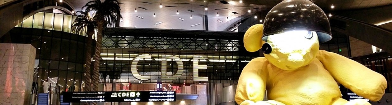
The new HIA is really nice; with some art installations and chosen furnishings and colors gave artistic and classy touch to this ultra modern airport. I got a chance to pass through Premium Terminal for Business and First Class. Nice gesture welcomed me when a waitress brought a cold welcome drink and cold towel while waiting to be served in a seated check-in counter.
After passing immigration then walked down to departure hall. I saw Harrods, and WH Smith at least have opened. An iconic “Lamp Bear” can’t be missed. Contrary to popular belief, a bus system still applies to ferry passenger to airplanes; at least for those depart from lower ground gates.
DWC is the second Dubai airport; which aimed at becoming the world’s largest logistics hub. Located just 22km east of Jebel Ali, it may not be suitable for tourists; less equipped and less connected than its neighbor DXB. A night taxi ride to TECOM area (Dubai Internet City metro station) costs 100AED (including 25AED airport surcharge) to give you an idea its location.
“Lamp Bear” at HIA
Premium Terminal
First Class check-in counters
View to front façade from Premium Terminal
No need to go London for Harrods souvenirs. Located at the base of escalator from Premium Terminal Immigration, or turn right as you enter departure hall
Playable “Playground ” installation near Mac internet area
Television area
Dubai Aquarium
Dubai. Can you see Burj Khalifa?
Dubai seen from above Deira
Dubai looking east
Business area and Dubai skylines. Burj Khalifa dominance can be seen here
“The World” islands are still unoccupied. Interested?
3 April 2013. It was the sixth day of us exploring Oman and that day was the time to say a goodbye to Oman as we were heading to Dubai. Consider it as a treat 🙂
We however liked to close the chapter with a trip to one of the most spectacular and favorites wadi in Oman: Wadi Bani Awf
Wadi Bani Awf
Wadi Bani Awf is located at the Batinah plain on the north face of Hajar Mountain and up to the spine of the mountain – a climb of over 2,000meters. Here, we’ll see a few remarkable villages along the way, twisting canyons, one of the most prettiest village and unparalleled view over the mountain as well as experience a frontier-feel offroad driving.
The route from Muscat started with following either Muscat Expressway or Sultan Qaboos Street and continuing to Muscat – Sohar road (Road 1). After about 42km from Seeb International Airport, turn left to Road 13 to Nakhl. Note: at the time of our visit, Road was undergoing redevelopment, making a left turn was not possible. Instead, we continued driving about few hundred meters before making a U-turn. Seemed like the roundabout will be demolished?). A turnoff to Wadi Bani Awf is actually located at about 4-5km from Al Awabi or overall 120km from Seeb International Airport.
We made a quick stop at Nakhl Fort before continuing to the wadi. There is a hot spring here in Nakhl if you have time to visit.
From the wadi turnoff, there is currently a good paved road 7km inward. After the pavemend ends, an offroad section starts and will only end at Sharaf Al Alamayn view point. The view point, that borders Al Batinah region and Ad Dakhiliyah region of Oman, offers commanding view over the mountain as well as to Balad Sayt village and Hat village. Having said that, a plan to upgrade the whole section of this mountain traverse is in progress. This way one from Sohar doesn’t need to go via Muscat to go to Nizwa. During our visit, some sections of the graded roads before and in At Tikhah village were being upgraded to paved road. We have been forced to wait for a good 30minutes as a blasting work was carried out.
Due to limited time, we didn’t venture deep into the wadi. We managed however to visit Little Snake Canyon. The canyon, derived the name from its twisting canyon, offers a good walk on the gorge, between boulders and finally clear and refreshing water pools.
To go to Dubai via Hatta, we took a road back to Road 13 and continued driving Rustaq (hence completing Nakhl – Rustaq loop) to go back to Road 1 Muscat – Sohar Highway. From Sohar, Oman border crossing in Hatta is 87km away. Rustaq, anyway, offers similar interests as Nakhl with its fort and hot springs.
Note: Road 13 from turnoff Road 1 via Nakhl up to Rustaq is a single carriage way. From Rustaq to Road 1 is dual carriageway.
Check Explorer’s Oman Off-road book for details of routes and other point of interests.
Nakhl FortWadi Bani Awf access is asphalted up to 7km. Construction undergoing to asphalt the offroad section all the way to Al HamraWadi Bani Awf – after 7-km asphalted road. But soon it will beA barrage of sign at Wadi Bani AwfWadi Bani Awf – near entrance to Little Snake GorgeWading through boulders and pools at Little Snake CanyonWadi Bani Awf – Little Snake CanyonImmersed in clear water pools in Little Snake CanyonOpening at Little Snake Canyon
Google Earth view of Little Snake Canyon (see black sections near the pin)
Nakhl Fort: N 23°23’42.0″ E057°49’43.0″.
Nakhl Hot Spring Car Park: N 23°22’36” E057°49’38.0″
Turnoff to Wadi Bani Awf: N 23°20’31.0″ E057°29’35.0″
Little Snake Canyon Entrance (car park): N 23°14’25.0″ E057°26’14.0″
A barrage of signs Wadi Bani Awf (see picture above): N 23°15’28.0″ E057°26’27.0″
Sharaf Al Alamayn view point: N 23°10’01.7″ E057°24’54.7″
Hatta and Hatta Pools
I purposely planned to go via Hatta from Muscat to Dubai with an idea to visit Hatta Rock Pools although I am fully aware that visa fee here is more expensive than in Al Ain (185AED compared to 135AED). Exit from Oman borders in Hatta was very easy; only one window for exit stamp. UAE (Hatta is a part of Dubai Emirate) border crossing was also straightforward. Although initially we were confused with queue owing to limited sign, we managed to get it right. We needed to go to a portacabin near Dubai Duty Free (consider it as arrival hall) first. Here we bought visa form and stickers. Then we had ourself lined up for eye scan and visa stamping, after completing the visa form. The only thing I can remember is that no vehicle customs inspection done – strange! The overall border process from exiting Oman border and finishing Dubai border process was between 40-50 minutes I guessed.
As Hatta’s UAE areas lies between Oman areas there are several checkpoints (UAE and Oman side-by-side) along the road. We only needed to show our passport. They don’t even bother to open or check our passport.
Hatta Rock Pools, our destination is actually located in Oman. So, one needs to go via a checkpoint. No need to worry as they don’t do checking. We prepared our passport but again they didn’t check.
The (graded) roads to rock pools were being upgraded at that time making driving to the destination was impossible. We turned back and headed to Dubai straight.
We visited the capital city of Oman the first time in 2009. It was a high summer month and Muscat was both hot and very humid; making outdoor tour of city becoming unpleasant. Now, we visited the city during spring and it was very much more pleasant. Muscat is a wide-spread metropolitan area that spans 3,500km2 (wikipedia); dominated by Western Hajar Mountain landscape. It is this nature setting that captivating the eyes of first time visitor; not modern settings or those high rise, skyscrapers.
We took a tour of the city that retains its traditional charms to Grand Mosque, Gate Museum, Al Alam Palace, Riyam Park, Qurm Beach and then continued driving to the city outskirts: Yiti and Bandar Al Khiran.
Sultan Qaboos Grand Mosque
Coordinate: N 23°34’54.7″ E058°23’20.3″
Unlike in 2009, access for mosque visit/tour was through front gate; passing a green garden to reach the main mosque structure.
Sultan Qaboos Grand Mosque from Sultan Qaboos StreetSultan Qaboos Grand MosqueSultan Qaboos Grand MosqueSultan Qaboos Grand MosqueMen Ablution – Sultan Qaboos Grand MosqueInner Courtyard – Sultan Qaboos Grand MosqueInterior of the mosqueSultan Qaboos Grand MosqueSultan Qaboos Grand MosqueOrnamental structure in the mosque
Riyam Park
Riyam Park is easily identified from its commanding incense burner monument just at the end of Mutrah Corniche Road. Unfortunately, the view point underneath the Incense Burner was closed. As we confirmed to the park keeper, it won’t be open; never, he said. Not sure why. As an alternate we spent exploring Riyam Park and enjoyed the view towards Mutrah Port and some sections of Corniche Road, and kids played on the playground provided.
Incense Burner and Water PotAt Riyam ParkView of Muscat Port from Riyam Park
Riyam Park: N 23°37’18” E058°34’47”
Muscat Roads and Malls
During our stay, we mainly drove two main artery roads in Muscat: Sultan Qaboos Street and Muscat Southern Expressway that runs almost in parallel but intersects at Qurm. From these two roads one can access nearly every corner of the city. The most lovely roads are from Mutrah Corniche to Old Muscat.
In regards to malls, Doha is probably in a better shape. We visited three malls: Qurm City Center, Muscat City Center, and Markaz Al Bahja. The last two malls are located quite distant from city center, just near Seeb International Airpot.
On one of the main streets in MuscatOn one of the main streets in Muscat, closer to old MuscatMutrah Souq near CornicheEntering Mutrah areaOman’s souvenirs – shown here at Al Qurm Complex
Qurm Complex: N 23°36’55” E058°29’50”
Qurm City Center: N 23°36’30” E058°29’23”
Muscat City Center: N 23°36’05” E058°14’56”
Markaz Al Bahja: N 23°36’51” E058°14’49”
Qurm Beach
Qurm means ‘mangrove’. The beach, below the Crowne Plaza Hotel, is well set up for visitors and has a number of picnic areas and palm shades. When the tide is low, one can take a 4km walk towards the Embassies’ area in Shati Al Qurum. It seems that the area is popular among locals. Youth crowded Al Shati Street parallel to the beach with their fancy cars. People was seen jogging the esplanade or sipping coffee at many caffe dotted along Al Shati Street, available beside natural mangrove areas.
Al Qurm area is also well-known for a home for Petroleum Development of Oman (PDO, like QP in Qatar) both office, recreation center, school or housing for its employee. I had a chance to visit PDO Club, courtesy of my ex-colleagues in Qatargas who is now working for PDO. The club has an excellent strip of beach between two cliffs/fjords and offers water-based activities as well as sports and restaurants.
Qurm Beach and Crowne Plaza Hotel in the backgroundSunset at Qurm BeachQurm Beach promenadeOmani & Lamp Post at Qurm BeachQurm Beach
Qurm Beach Parking: N 23°37’30.3″ E058°28’48.9″
Gate Museum
Opened in January 2001, the museum contains displays about Oman’s history from the Neolithic times to the present. It has a number of special exhibits on Muscat’s water springs, the ancient wells, underground channels, the souks, houses, mosques, harbors and forts. Try a video (complemented with marked oversized terrain map of Muscat) that takes you to a journey of Oman’s history.
Muscat Gate where Gate Museum is located (Source: Wikipedia)Gate MuseumView of Corniche Road from Gate MuseumCorniche Road from Gate Museum
An interactive video on Oman and Muscat History
Gate Museum Parking: N 23°37’02” E058°35’10”
Al Alam Palace
Al Alam means “the flag”. It is the ceremonial palace of His Majesty SultanQaboos of Oman.
The palace has a history of over 200 years, built by Imam Sultan bin Ahmed the 7th direct grandfather of the current Sultan.The existing palace, which has a facade of gold and blue, was rebuilt as a royal residence in 1972.Visitors are not allowed inside the palace, despite the fact that His Majesty normally lives elsewhere in Oman, but it remains a popular area to walk next to and take photos. Al Alam Palace is surrounded by the Mirani and Jalali Forts built in the 16th century by the Portuguese. The Palace is used for official functions and receiving distinguished visitors. (Wikipedia)
I took an advantage of being a tourist by temporarily parking just in front of the gate to the palace. Not sure if it was allowed though. Otherwise visitors may park at nearby car parking area between Al Saidia Svhool and Directorate-General for Communication and Information Systems.
Nearby attractions include: Bait Al Zubair Museum, Omani French Museum and Mirani and Jalali Forts.
Al Alam Palace Car Parking: N 23°36’46.6″ E058°35’34.0″
Al Alam Palace Gate: N 23°36’45.4″ E058°35’38.0″
Al Alam Palace
Yiti Beach and Bandar Al Khiran Beach
The beaches in Yiti and Bandar Al Khiran, being close to Muscat, are good for an easy half-day trip from Muscat. There are good networks of roads connecting Muscat to Qantab, Bandar Al Jissah, Yiti, Bandar Al Khiran (or Bandar Khayran) and finally As Sifah. All of them have many good beaches. Unfortunately, following the success of Bandar Al Jissah, Qantab, Yiti and Bandar Al Khiran are now undergoing massive property development. I am afraid these beaches will no longer be accessible by public, except by those who stay. Qantab Beach (we visited in 2009) is currently closed for the development. Yiti is also the same although we can still access a public beach near the village. But across an inlet, a development is under full swing (Yiti Bay Development and Salam Yiti Resort Development).
Road to QantabRoad to YitiThe village of YitiYiti Beach – the better one is near to end of village roadA secluded beach at Bandar Al KhiranBandar Al KhiranBlack mangrove at Bandar Al KhiranRoad to Bandar Al Khiran
Qantab Beach: N 23°33’04” E058°38’37.0″
Yiti Beach: N 23°31’56.6″ E058°40’56”
A secluded beach opposite Yanket village (on the way to Bandar Al Khiran): N 23°31’06” E058°42’18”
Bandar Al Khiran Mangrove : N 23°30’47.7″ E058°43’14” – this was where I took the mangrove area picture above.
As Sifah village: 23°26’0″N 58°46’52″E – the beaches are located both on the left and right.
We woke up reluctantly as if our eye lids hung with a kg of dumbbells. But show must go on; we’re so excited. I guessed we were one of the only few guests of this hotel opted for Turtle Watching at 4am. The road was so quiet and dark as we started to drive to Ras Al Jinz, 22km away. Less than 20min after we arrived at the reserve. We’re instructed to be here at 3.45am yet no one was available at 3.35am. It wasn’t until 4am that the reserve staff was available. Slowly the reception hall was filled with participants. A group of three families were seen arrived without prior booking advised that booking was full. Nevertheless they were instructed to wait.
I understand from turtle watching tour review that there will normally be three groups at each session. Each session can accommodate up to 100 people. Hotel guests (Ras Al Jinz provides accommodation; but gets easily fully booked) are given the first priority. As part of their room fare, they can choose to participate in two tours without additional fee.
We waited and waited and started to be restive when the time showed 4.30am. Yet, no instruction given to gather. Until….
“Good morning ladies and gentleman. Thank you for your interest in turtle watching and be patient with us. Apologize for delay. Our staff have tried their best twice to find turtles but unfortunately they are not available. This is nature and beyond our control.”
Oh my…..this wait’s over. My boys couldn’t hide their disappointment. But he is right, this is nature and beyond our control. Shall we make an appointment hi green turtles?
During our visit to Turtle Museum a day before we come to know that the best and peak egg laying (nesting) season for green turtle is during the summer months of July and August. During this period we may expect great numbers of turtles.
At Ras Al Jinz Turtle Nature reserve – waiting for Turtle WatchingGreen Turtle at Ras Al Jinz (Source: Wikipedia)
Ras Al Jinz Turtle Nature Reserve: N 22°25’33.0″ E059°49’38.0″
Turtle Beach Resort
This resort is one of the options if Ras Al Jinz accommodation is fully booked. Other alternative will be Ras Al Hadd Holiday (across the bay) or further up in Sur (40km away). Although the resort bears a name of Turtle Beach – and this is misleading – no turtles are coming to this beach. I think they are taking an advantage from the famous turtle watching tour in Ras Al Jinz.
The resort, anyway, provides a standard quality accommodation. There are options of shared bathroom or en-suite bathroom. All options gives half-board facility with dinner provided at restaurant and breakfast at their meeting hall. What they call a beach is basically a less than 100m beach situated at Khawr al Hajar (a quiet lagoon in Ras Al Hadd). At the time of our visit, unfortunately, the beach was full with jelly-ball like marine organism that it became unusable for swimming. I provided a quite lengthy review in booking.com for the resort.
A short strip of beach at Turtle Beach Resort – Ras Al HaddTurtle Beach ResortTurtle Beach ResortA typical room at Turtle Beach ResortSocial media victims 🙂Dinner at Turtle Beach ResortTurtle Beach Resort at night
We checked out from Turtle Beach Resort and headed to Muscat via Sur. Muscat is about 200km from Sur through East Coast Highway. Sur is a quiet town surrounds the ancient harbor. Highlights of Sur are shipbuilding yard, and dhow museum. We didn’t visit the museum and yard though; instead we took a driving tour encircling the inlet as well as to north corniche area where Sur Beach Hotel is located. From here, the road is connected to Sur – Qurayyat Highway and then Qurayyat – Muscat Highway.
A bridge that links Sur and Al AyjahA view across Sur lagoon from the bridge. On your right is dhow building yardSur inlet to Sea of OmanFatah al Khyr, a fine example of a ghanjah, one of the largest classes of seagoing dhows
Dhowyard: N 22°33’43.0″ E059°32’12.0″
Dhow Museum (Fatah Al Khyr Yard): N 22°33’40.0″ E059°31’53.0″
Wadi Tiwi
From Sur, we continue driving northwardly on Sur – Qurayyat Highway passing Oman LNG, and ancient town of Qalhat. About 40km from Sur we arrived at Wadi Tiwi. We turned off from the highway, drove under the bridge and up the wadi. The initial sections of Wadi Tiwi are concrete paved in a wide good road. As soon as it enters the village of Harat Bidah, the road climbs steeply and the pavement ends. We couldn’t resist take a plunge into crystal clear water amidst green plantation and the surrounding rocky mountain.
Now we had a story here. As we tried to go further up the wadi we entered the village. Seemed like I took a wrong turn. Instead of going left, I was going straight. This led to a dead end and I couldn’t either move up or down from this one-vehicle wide road; blocked by parked cars and constrained by a ravine on the left and a wall on the right. Fortunately, Omani people are so humble and nice. Knowing our difficulty they tried to manage us to go back by manoeuvring parked cars in very tight spaces. We’re finally relieved and ready to go back to the right route when one pick-up was coming into our direction. Upps.
The pick up insisted to move forward and gave a code to passing him. I thought what? How come. The driver was actually driving his car almost near to the ravine and left both our cars just an inch to pass. Not really an inch as I heard a screeching sound when I tried to squeeze and pull my car from this passing. I stopped but it seemed like the pickup driver continued pulling his car. Oh my…the screeching sound became louder and I could only resign to the situation.
We found out later that better than what we expected, it left only a little mark; peeled off paint on rear door handle.
We left Wadi Tiwi with a bad mood and decided not to continue the adventurous route up the wadi. We even missed our plan to go to Wadi Shab just 2.5km apart. Wadi Shab has more spectacular geographical location and background. Ahh…
Highway Bridge at the entrance to Wadi TiwiThe road to Wadi TiwiCan’t resist of crystal clear waterLush plantation and rocky landscape
Wadi Ash Shab Car Park: N 22°50’21” E 59 14’46”
Wadi Tiwi (entrance near the bridge): N 22°49’24” E 59 15’34
Sink Hole
Bimmah Sinkhole (40mx60m app.) is a deep natural depression filled with water, called Hawiyat Najm. The (Hawiyat Najm) park is situated in the Dabab area of Wilayat Qurayat, Muscat Governorate, and can be reached via the road linking Qurayat to Sur. The park is dotted with palm trees and several gazebos; a great place to stop and have lunch – as we did.
A short walk from the parking area leads to the sinkhole. A low wall is provided around the sinkhole to keep the visitors at bay. Unlike in Qatar, the sinkhole here is filled with salty water due to its connection with open sea 500m away. It is a quite deep water but that doesn’t prevent some visitors to take a plunge. Who can’t resist vibrant turquoise water in a quite hot day? I can 🙂 Many people seen swimming, jumping from height and diving.
A visit to Sink Hole closed our trip across East Coast.
Hawiyat Najm Park where Bimmah Sink Hole is located atAt Bimmah Sink HoleSink Hole – view towards background mountainWho can resist to take a plunge to vibrant turquoise water?Google Earth view of Sink Hole. The hole is connected to the sea 550m away
Sink Hole Turnoff: N 23°02’29.0″ E059°04’23.0″
Sink Hole Car Park:N 23°02’12.5″ E059°04’12.7″
Ruwi View Point
We took a detour to Ruwi View Point on the way to our hotel, Midan Hotel Suites. The view point offers a sweeping view of Ruwi and Wadi Al Khabir. This can accessed from Yiti Street and follows a 1km rough offroad. There is a small parking area before the stairs leading to top view point. The last section of offroad can be a tricky due to its steep climbing and presence of small slippery stones.
Access to Ruwi View PointOffroad section of Ruwi View PointStairs to Ruwi View PointView of Ruwi and Wadi Al Khabir from lower part of view point
Turnoff Ruwi View Point: N 23°33’22.0″ E058°34’05.0″
Misfat Al Abryeen. See how pretty the village is. (Photo: Helly Purwanto)
….a day before…
We arrived at the small parking area at the edge of the village of Misfat Al Abryeen at around 4.30pm to check-in into Misfah Old House. This is located about 8.7km from Shell Petrol Station, Al Hamra through switchbacks. The village itself is set above terraced plantations of date palms in stunning landscape of rugged mountain.
On the instruction that sent by Misfah Old House Hotel we were advised to check in before 5pm or before dark and to contact them at least 30min before arrival for escort. For a good reason. The hotel is located deep down (though only 5 minutes walk) into the village with no directions. It is no way for the first timer to reach the hotel without their guide. It gets very dark at night and can be quite dangerous for navigating flights of steps.
From the parking area, we only see a single street. Soon, the road ends and the rest are a cool maze of meandering lanes, gateways, covered passageways and flights of steps, until sooner or later comes to a falaj or plantation area. Just before the parking area, you will see the below sign; reminding visitors not to take their car into the village. The end of the road is however only 170m from the parking area.
Please respect the village!The road soon ends after this point. On the right is visitor information center. Visitors dragging their luggage to check-in to Misfah Old House can also be seenMap and Visitor Information of Misfat Al AbryeenMisfat Al AbryeenCheck-in in style through meandering alleysEntering into covered passagewayEnd of road in Misfat Al AbryeenVisitor Center at Misfat Al AbryeenSo..this is the hotel: Misfah Old HouseArrived at Misfah Old House. Welcomed with qahwa and dates in the reception balcony overlooking plantationOur room in Misfah Old Hotel. No TV. No Furnitures.A roof-top balcony – above our room – overlooking plantationLocking the old way, using padlock and key 🙂Meet Mohammed, one of the excellent staffs in Misfah Old HouseDinner at roof top – Misfah Old House
Misfat Al Abryeen
Misfah Old House is ex-abandoned houses converted into a hotel only about 2 years ago. The owner, now resides in Australia, renovated these houses; turned a veranda into a reception room, fitted AC, and constructed a restaurant and balcony on roof top overlooking plantation and falaj. The result is a basic, rustic Omani style hotel. The conversion is not without controversy as the local villagers expressed concerns about commercialization, culture intrusion as well as lost of privacy.
In the morning, we made a short trekking tour around the village by following already established trekking paths (marked by a red-white-yellow band painted on intervals on stones). The path behind the hotel will lead you to eventually a gorge while the opposite path leads back to the village, bath areas, and a view point. Along the paths is one of the most intricate falaj network in Oman that snakes around the plantation.
Misfat Al Abryeen Car Park: N 23°08’26.0″ E057°18’38.0″
Misfah Old House: N 23°08’24.1″ E057°18’44.9″
Misfat Al AbryeenMorning trekking in Misfat Al AbryeenOne of the prettiest village in OmanFalaj network in Misfat Al Abryeen. Don’t be surprised to see clothes on falaj. They are meant to stop water flowAnother view in Misfat Al AbryeenLush plantation and rocky mountainView from Star View Point
Al Hamra – Wahiba Sands
After a simple breakfast at Misfah Old House, we started hitting the road; leaving Al Hamra and Ad Dakhiliyah region to go to Ash Sharqiyah region (literally means Eastern Area). We stopped by at a medium supermarket opposite Shell Petrol Station and greeted by and caught in a conversation with turned out to be ex-Doha resident.
Al Hamra seen from road to Misfat
The route to Wahiba (Ash Sharqiyah region) from Al Hamra follows Nizwa – Bahla road (Road 21), turns left at Jibreen Intersection to enter Jibreen-Nizwa Highway (Road 15) and continues until Izki to turn right to Road 33 (to Sinaw). There is a shortcut road (rather than through Sinaw) about 27km before the town that links to Road 27. And finally driving a road that links to Road 23 (Ibra) and follows southwardly to Wahiba Sands.
We stopped by very briefly at Bahla Fort. Bahla Fort is one of four historic fortresses situated at the foot of the Djebel Akhdar highlands in Oman. It was built in the 13th and 14th centuries, when the oasis of Bahla was prosperous under the control of the Banu Nebhan tribe.
Bahla Fort
Wahiba Sands (or the road signs show as Ash Sharqiyah Sands) is basically a region of desert named for the Wahiba tribe. The area is defined by a boundary of 180 kilometers north to south and 80 kilometers east to west. Wahiba to Oman is what Inland Sea is to Qatar. We didn’t venture out deep into Wahiba Sands – it’s quite hot at that time amidst still in early April.
Several desert camps offer desert stay experiences, 7km up to 20km into the desert, such as Al Areesh Camp, Desert Nights, Nomadic, and Al Raha Camp. The desert can also be accessed through several villages dotted along Ibra – Al Kamil road such as Al Wasil, Al Mintarib or Al Ghabbi. The most popular turnoff is Al Mintarib.
Wadi Bani Khalid, located 25km from main road from Wahiba to Sur, can be an option worth visiting if you have time. The area is very popular for swimming, wadi hikes and cave exploring.
Bahla Fort: N 22°57’52.0″ E057°18’02.0″
Wahiba Turnoff via Al Mintarib: 22 27’06″N 58 48’41″E
Wadi Bani Khalid Turnoff: 22 39’38″N 58 56’16″E
Wahiba SandsWahiba Sands
Ras Al Jinz: Turtle Museum
Ras Al Jinz is home to Turtle Nature Reserve, the main if not the only attraction in here.
One-and-half hour or so driving (125km) from Wahiba we arrived in Sur, the esternmost major town in Arabian Peninsula. Ras Al Jinz is about 40km further to South South East (SSE). At the T-junction from Sur that leads you to Ras Al Hadd or Ras Al Jinz, turn right and follow the signs. At the signpost for Ras Al Jinz past a GSM tower on your left, take the left turn and drive another 6km to the reserve. You will pass Al Naseem Tourist Camp on your left, 1.5km after your left turn.
The Reserve offers two sessions for turtle watching: 9.30pm and 4.30am. These are designed because of Government rules to limit human disruptions to peak turtle egg-laying period (11pm – 4am). The 9.30pm timing will not allow participant to take photographs/use flashes to avoid making navigation confusion to the turtles. The morning session allows photographing. A unique display of the impact of light to turtles is available in the Museum
We arrived at the reserve around 3pm and made our booking for morning session. No need to pay during this booking except you are given a reference number for later registration. Turtle watching fee otherwise is 3 OR.
The reserve also has an interesting turtle museum – everything about turtles – on its second floor of the building. Fee is 1 OR per adult, children is free. Automatic proximity audio guide – available in multi language of your selection – is really helpful in understanding all displays in the museum. It is said that The Ras Al Jinz beach is world renown for the nesting endangered green turtle (Chelonia mydas), probably the most important nesting concentration on the Indian Ocean. This is the only place where the public can watch the nesting process of these amazing sea giants. In the museum don’t forget to test your knowledge on Turtles just at the end of your museum visit. Can turtle breathe underwater?
Ras Al Jinz Turtle Nature Reserve: N 22°25’32.0″ E059°49’38.0″
I slept like a rock last night after long hours driving. This was enough to recharge my stamina to tackle Day 2 itinerary. I was so impatient!
Al Ayn Beehive Tombs
Together with the neighbouring sites (Bat, & Al Khutm – not visited), Al Ayn (not to be confused with Al Ain – UAE) forms the most complete collection of settlements and necropolises* from the 3rd millennium B.C. in the world. The tombs in Al Ayn however were quite spectacular, strung out in a long row along a ridge overlooking the wadi. Wadi is the Arabic term traditionally referring to a valley. In some cases, it may refer to a dry (ephemeral) riverbed that contains water only during times of heavy rain or simply an intermittent stream.
We traced back a road than links Ibri to Bahla to reach Al Ayn. We drove this road a night before. Unlike last night, we could see clearly the road condition and its rewarding scenery. Along the road, construction is undergoing to expand it into a highway. I don’t think it’s gonna finish within a year though.
There are two turnoffs to Al Ayn from Ibri – Bahla road. Each one is closer to either Ibri or Jibreen although eventually they are mingled at Al Amla into one leading road to Al Ayn and Wadi Damm. The turnofss are located approximately 40km from either side. From here Jibreen side turnoff, the tomb is about 22km through a single carriageway, and can be easily identified once we approach Al Ayn by a long row of tombs with impressive backdrop of Jabal Misht (or called Comb Mountain).
If you have time, a trip to Wadi Damm, 12km further down the road and 30-40 minutes walk, may be worthy to see pools and do hiking.
*Necropolis: (Greek plural: necropoleis; Latin plural: necropoles) is a large cemetery or burial ground, usually including structural tombs. The term comes from the Greek νεκρόπολις – nekropolis, literally meaning “city of the dead”.
A long row of necropolis of Al Ayn with impressive backdrop of Jabal Misht (Comb Mountain)Trekking to Beehive TombsThe village of Al Ayn seen from beehive tombsA closer look of beehive tombsAt Al Ayn Beehive TombsAl Ayn Beehive Tomb is overlooking a wadi
Jabreen Castle
Jabreen Castle lies 20km from Bahla or 4km south of Jibreen Hotel. From Ibri – Bahla road, Jibreen (Hotel) Intersection, follow southwardly passing a roundabout that gives an access to a highway to Nizwa. After about 4km from Jibreen Intersection, turn right at the next roundabout.
Jabreen Castle was built primarily by Imam Bil’arab bin Sultan Al Ya’rubi around 1670AD when he moved his capital from Nizwa to Jabreen. Imam Bil’arab died at Jabreen in approximately 1692 and found eternal rest in a tomb inside the castle. Muhammad bin Nasr Al-Ghafiri resumed building activities made alterations in the castle in 18th century AD. Jabreen Castle was restored between 1979 and 1983 by the Ministry of Heritage and Culture.
This castle was a beautiful palace for the Immam and his family and a bastion during wartime. It was also a beacon of education and contained many study rooms. The palace is a large rectangular building consisting of five floors and containing 55 rooms. A Falaj runs through the middle of the castle. This castle is distinguished by the inscriptions and frescoes that adorn its rooms. The castle’s ceilings are decorated with paintings and Islamic-era style inscriptions, and its doors are beautifully carved. All these architectural details make Jabreen Castle an authentic expression of Omani craftsmanship. Jabreen Castle is divided into two parts: the first rises for sixteen metres and consists of two storeys, whereas the second part rises to twenty-two metres and consists of three storeys. The castle’s rooms are divided between these two sections. The most beautiful and unique of these rooms are:
The Sun and Moon Room: This was the room where the Immam met important visitors for discussions and consultations. What distinguishes this room are those icons and beautiful Islamic calligraphy adorning its ceiling, particularly the eye drawing. It contains 14 windows, seven of which are located at the top near the ceiling and seven are at the bottom. Here lies the secret of the room’s cool atmosphere throughout the year, as when cold air enters from the lower windows, it expels the warm air from the top windows
Immam Protection Room: Another distinctive room in this palace. This room was built in a way that allows the Immam’s soldiers to hide underneath it for his protection when he wished to meet with any person he did not trust. There are four secret hideouts under the room connecting with each other
Internal yard of Jabreen CastleJabreen Castle EntranceInside Jabreen castleImam’s Room characterized by Islamic caligraphyTraditional crafts on display at Jabreen Castle
The castle is overlooking plantation
Fathan under arrest 🙂Jabreen Castle Plan
Nizwa – Falaj Daris
From Jabreen Castle, we were heading to Nizwa through a 32km-highway. Our plan was to visit Nizwa Fort, pack a lunch from Nizwa before heading to Wadi Nakhur and Jebel Shams. Not much changes to Nizwa since we visited the town 4 years ago although 3-5 km before Nizwa city center, I saw many more commercial centers sprung up than I saw in 2009. If you plan to pack a lunch from Nizwa it’s better to have it in here than in Nizwa city center, which is basically the old part of town. We parked at a one-way street beside Nizwa Souq and walked to this 17th century fort. We soon realized we took a wrong direction and happily abandoned the plan to look inside; and took pictures from outside instead. We went into Nizwa Souq back in 2009 and found it was very interesting to see many examples of the local silversmiths’ art, especially engraved khanjars, or of the local pottery.
Finished packing our lunch at one of traditional restaurants overlooking Nizwa Souq, large yard and Nizwa Fort backdrop, we decided to have our lunch in Falaj Daris, at outskirt of Nizwa, 6.5km app. from the Book Roundabout. Falaj Daris is basically a garden park or picnic site by the wadi with playground, small cafeteria and many gazeboos and grassy lawn. Nothing special though.
Nizwa Fort: N 22°55’59.0″ E057°31’47.0″
Nizwa Souq: N 22°55’56.0″ E057°31’55.0″
Book Roundabout: N 22°56’11.7″ E057°31’50.3″
Falaj Daris: N 22°58’17.7″ E057°32’56.6″
Falaj Daris, Nizwa. Stopping for lunchBook (Al Kitab) Roundabout – a famous landmark and reference point in NizwaNizwa City Center – Nizwa Souq, Nizwa Fort and Grand Mosque
Al Hoota Cave
Check before heading to this cave. At the time of our visit, the cave was still under renovation/maintenance. The status is rarely or if not never informed on their website (http://www.alhootacave.com/) so it’s better to check directly by send them an email or phone them.
Otherwise, the cave offers unique experiences of visiting over 2 million years old stalagtites and stalagmites, underground lakes and its rare blind fish.
Al Hoota Cave Car Park: N 23°04’52.0″ E057°21’01.0″
Wadi Nakhr gorge
The start of Wadi Nakhr track is located about 9.7km from Shell Petrol Station at Al Hamra roundabout. As the road branches to the graded track in Wadi Ghul, one may look into to two contrasting worlds. On the left is the old stone houses on the hill side (blend in rather well with the background scenery) whereas separated by wadi is the new modern houses. I was busy taking pictures of old houses when two young Omani boys got off from a minivan. Seems like they are schoolboys. Our eyes followed them closely; walking down to wadi, crossing the wadi, splitting to different paths to their home. We saluted them for their perseverance to study.
We continued our drive into the entrance of Wadi Nakhr. This was our first wadi drive and we’re wowed by the contrast scenery, and by a narrow and imposing opening to the Grand Canyon. A rough graded track then continued its route climbing hairpinly through the village of Al Hijr. After this ascending drive I took a brief break to enjoy the wadi as two village girls approaching our car trying to sell a piece of rug knot. The area is well-known for the high concentration of rug weavers. They were kind enough to share their smiles.
After passing this village, the walls of the canyon become narrower and soaring higher above us. The road also becomes rocky in part and steep. We didn’t continue until the end of wadi and decided to go back and continue tarmac road to Jebel Shams summit view point.
Wadi Nakhr Entrance: N 23°08’57.0″ E057°12’17.5″
Old Wadi Ghul houses that left by the villagers for more modern life just across the wadiEntrance to Wadi NakhrAnother view of Wadi NakhrThe locals of Al Hijr villageWadi Nakhr
Jebel Shams (view point)
Jebel Shams (mountain of sun) is the highest mountain in the country, with peak elevation ranging from 2,980m to 3,075m. It is a part of Al Hajar Mountain range.
Jebel Shams view point is located approximately 39km from Shell Petrol Station, Al Hamra and can be reached between 30-45 minutes. The road to the top is mainly tarmac road (32km) which interspersed by a 7km graded track before the last 5km. The road is quite as we climbed up. We passed a water truck running at a snail pace that we jokingly bet that we would meet it again on our way down. And that’s true! When we finished our trip to the view point for an hour or so we met the same truck. The driver looked powerless as if he said no matter how hard I pressed the gas it won’t run faster than this.
The view point itself is located about a km before Jebel Shams Resort. Look out for a GSM tower and small building below it. From this view point that barricaded with strong wire fences, we can see Jebel Shams peak, Grand Canyon and further down some villages at Al Hamra areas. In addition to Jebel Shams resort we saw a new hotel under construction – Jebel Shams Heights – that will provide an alternative for a popular resort. The resort is a good base if you plan to do trekking. Otherwise I’d suggest that you have a day trip and make a base in Al Hamra or Nizwa.
Jebel Shams view point at elevation of 2021m aslFathan and Faiq are being chased by the peak keeper 🙂Elevation 2021m. Look for that GSM tower for view point
Jebel Shams view point area
Oman’s answer to Grand Canyon
—
We descended from elevation of 2,000m and leisurely drove back to Al Hamra to go to Misfat Al Abryeen. Here lies one of the most prettiest traditional villages in Oman. Our hotel is located inside this mountainside village.
Next: Misfat Al Abryeen, Bahla Fort, Wahiba Sand and Ras Al Jinz.
We arrived at Jibreen Hotel, Bahla, Oman at around 8pm, after a journey trip of more than 18hours from Doha. It should have been shorter, had we shortened our break in Abu Dhabi. We spent 4 hours in the capital: meeting friends, Friday prayer and lunch break.
I purposely made a plan to take a break in Bahla after completing all 6 borders in one-day go. But it meant long hours of driving.
It was only 2am when we started hitting the road in Doha towards Bu Samra: Qatar – Saudi border. In this wee hour, everything was quiet, and speedy, including the normally long Saudi border process. Less than 20min! A record time.
Beware of Oncoming Traffic
Literally. A road between Qatar/Saudi border and Saudi/UAE border is a dual carriageway dual lane separated by nothing other than non-asphalted land strip, without physical barrier. The road is also not equipped with street lamps. Driving this 125-km stretch was pleasant; although the road is asphalted rough but they are still okay. Until…..
I was driving on fast lane/left lane. Fully concentrated to the road, my retina widely opened. Traffic was scarce with few cars passed every two or five minutes. Until suddenly few hundred meters upfront I saw three cars travelling in a group moving towards me. I kept on the left assuming that they were travelling on the other side of the road. As we approached each other, the frontmost car gave flashes of light. What? Am I driving on the wrong road? Was the road mingled I was not aware of? So, I decided to move to the right lane just 5-10 seconds before they passed. Hundreds meters down the road I was still thinking if this is single carriageway or was I driving on the wrong side. No. Indeed they were driving contraflow and they asked for a way!
It is not uncommon for this type of the road that the road users are driving contraflow incidentally or making a U-turn anywhere they like. Beware. It is safer to use this Saudi-UAE road only during daylight.
Petrol Stations
If you zero your odometer right at Qatar border you’ll find at least three petrol stations on Saudi-UAE road: km 58, km 101, and km 136 in addition to one right after Saudi border. So don’t worry much about running out of fuel. Well, if you like to save some bucks, fill full in Saudi before entering UAE: .65 riyal per liter in Saudi and 1.6 in UAE.
It’s Friday
This is the second time we travel across UAE border on Friday. But this time is different. For something that I don’t know, UAE border process takes double the normal time. We arrived at around 6.20am (UAE time). Entering the Arrival Hall to obtain visa on arrival, I saw no visa seekers except us. We were handled directly by the only immigration desk officer. Completed visa form we were back to have iris scan. This is the problem. Although there is one officer in Iris Scan Room we were not able to proceed, I didn’t know why. We waited for about 45 minutes. I saw many times that the officer tried to make a call. Seems like he was waiting for higher ranks to come. And that’s true. We were only able to proceed after two higher rank officers arrived. A total of two hours was spent in UAE border alone. Fiuuhh.
140km/h
There is nothing change along Road E11 that linking Saudi/UAE border up to Dubai. I have mentioned in another post that I was confused on speed limit applicable to the road. Speed sign bears 120km/h but signboard bears 140km/h. Learning from my googling that “sometimes” limit allowance is given to stated limit of up to 20km/h (where speed camera actually flashes), I drove with assumption that the signboard is right. It took me exactly three hours from UAE border to Abu Dhabi Corniche.
Mezyad, Al Ain
Mezyad is the name of UAE border to Oman in Al Ain, a city 160km east of Abu Dhabi. The exit process from UAE is simple. On the first booth, car registration is asked, but no slip (custom permit) is given. At the second booth, pay exit visa 35AED per passport. And that’s it. No other checks. In Omani side, the border process is not that difficult. Go to Immigration Building, present your passport, fill-in visa form, pay insurance (at the same building) and visa and get your passport stamped. I learned that children are now (compare to 2009) required to have a separate visa form.After that couple of checks for passport as well as custom inspection.
Mezyad UAE Border: N 24°01’36.9″ E055°50’46.4″
Mezyad Oman Border (Departure/Arrival Hall): N 24°00’50.1″ E055°50’48.2″
Al Ain – Ibri – Bahla
From Mezyad border, Ibri is 130km away through a highway; while Jibreen, Bahla is another 90km. We initially planned to stay in Ibri knowing that the first stop is Al Ayn Beehive Tombs, located inbetween Ibri and Jibreen, Bahla. Unfortunately two hotels in Ibri were not available through booking.com so that we shifted our plan to Jibreen, Bahla. Ibri-Bahla road is a wide single carriageway without street lamps. Learning from what I had experienced, I don’t recommend driving this road section at night; scenery during the day is more rewarding, and it’s safer and less tiring of course.
If you opt to stay at Ibri, try to visit Ruins of Al Sulaif Fortress Town located a kilometer after Ibri if you are driving from Al Ain. Coordinate: N 23°12’17.0″ E056°31’34.0″
Jibreen HotelJibreen HotelSurrounding Jibreen Hotel
Other alternatives include:
Ibri Oasis Hotel,9km from Ibri town centre on the road to Al Ain. Coordinate: N 23°14’56.0″ E056°24’51.0″. Driving from Ibri, you’ll find it on the right hand side of the road, just after the College of Technology and Sports Complex. Reservation not available through booking.com. can be made through telephone: +968-25696172/25696173/25696174, fax number is +968-25696171, email address: iohotel@omantel.net.om.
Al Majd Hotel Apartment, Ibri. Located near Ibri’s Police Headquarter.N 23°12’55.0″ E056°29’11.0″ http://www.almajdhoteloman.com/
I’ve just arrived from yet another driving trip across neighboring countries. This time was to Oman with a short break in UAE. The focus is on Offroad Oman; following in many cases routes suggested by Explorer Publishing’s Offroad Oman book.
I try to document this trip into travelogues but I don’t think they will be materialized until next week. I will be busy with acting Head of Loss Prevention Engineering then after office hours taking a full week 6-9pm free course on How to Invest in Stock Market by Faculty of Islamic Studies & Qatar Exchange.
Until next week, here are some interesting facts and figures from the trip:
Distance Covered: 3700km
Fuel Cost: 724 QAR (normalized to QAR assuming 1 QAR = 1 SAR = 0.1 OMR = 1 AED). Petrol with Super grade: Qatar 1 QAR/liter, Saudi 0.65 SAR/liter, UAE 1.6 AED/liter, Oman 0.120 OMR/liter)
Routes: Doha – Abu Dhabi – Ibri – Jibreen – Nizwa – Jabal Shams – Al Hamra – Bahla – Wahiba Sand – Sur – Ras Al Jinz – Muscat – Nakhl/Rustaq – Sohar – Hatta – Dubai – Doha.
The 3,700km-route of Offroad Oman 2013
Objects Visited:
– Al Ayn Beehive tombs
– Jabal Shams
– wadi Al Nakhur
– Misfat Al Abryeen
– Nizwa Fort
– Falaj Daris, Nizwa
– Jibreen Castle
– Bahla Fort
– Wahiba Sand
– Ras Al Jinz Turtle Conserve
– Sur City
– Wadi Tiwi
– Sink Hole, Bammah
– Muscat City
– Nakhl Fort
– Wadi Bani Awf
– Hatta Pools
– Dubai City
Total Expenses: 9700 QAR (for a family of 4 for 7 nights 8 days trip including accommodation, meals, visas, attractions (mostly nature objects, free museums & parks, SEGA Republic – 160AED per person), fuel and transport, Oman souvenirs)
Visas:
– Saudi Transit Visa: 150 QAR per passport
– Saudi Insurance: 100 SAR for 2 weeks
– UAE Visa (Ghweifat border; Abu Dhabi Emirate): 110 AED per passport
– UAE Insurance: 100 AED for 10 days
– Oman Visa: 5 OMR per passport
– Oman Insurance: 8 OMR for one week
– UAE Visa (Hatta border; Dubai Emirate): 185 AED per passport
– UAE Exit Visa: 35 AED per passport
Accommodations:
– Jibreen Hotel, Jibreen: 50 OMR per night (incl breakfast, free wifi)
– Misfah Old House, Misfat Al Abryeen: 49 OMR per night (incl breakfast, dinner, 16% tax & service charge)
– Turtle Beach Resort, Ras Al Hadd: 74 OMR per night (incl breakfast and dinner, 17% tax & service charge)
– Midan Hotel Suites, Muscat: 98.1 OMR for two nights (incl breakfast and free wifi, kitchenette, 9% tax)
– City Stay Hotel Apartment:1080 AED for two nights (inc free wifi, kitchenette, 20% tax & service charge)
Day 5. 10 April 2012. Our last day in Abu Dhabi. We spent visiting Sheikh Zayed Grand Mosque, Sheikh Khalifa Park, passing through Capital Gate Tower, visiting Qasr Al Hosn (unfortunately closed), having lunch at Sari Rasa Indonesian Restaurant, souvenir shopping at Hamdan Center, peeking into The Souk Central Market (newly open), visiting Emirates Palace then Marina Mall, Heritage Village and Breakwater Area, and enjoying sunset overlooking Etihad Tower and Emirates Palace. Along the way, passing through corniche and driving around grid-system of Abu Dhabi roads. wrapped the day with dinner at Al Wahda Mall, just side-by-side with our Grand Millenium Hotel Al Wahda.
Here are some pictures.
Sheikh Zayed Grand Mosque
Sheikh Zayed Grand Mosque (from south parking side)Gold-plated pillars at Grand MosqueThe Sheikh Zayed Grand Mosque has seven imported chandeliers from Germany that incorporate millions of Swarovski crystals. The largest chandelier is the second largest known chandelier inside a mosque, the third largest in the world and has a 10 m (33 ft) diameter and a 15 m (49 ft) heightThe courtyard with its floral designParts of the world's largest carpetOne of the chandeliersOne of the mosaic tiles in Grand MosqueMen's ablution
Abu Dhabi City
Sheikh Khalifa Park
Grand Mosque seen from Sheikh Khalifa ParkCapital Gate Tower or Leaning TowerA mosque in Qasr Al Hosn (currently closed for renovation)Oh my...found the best 'gulai padang' in GCC here in Abu Dhabi - Restaurant Sari RasaThe Souk Central MarketInside The Souk Central Market
Emirates Palace
Emirates Palace's Grand ArchEmirates PalaceInside Emirates Palaceanother shot inside Emirates PalaceEmirates PalaceEtihad Tower with Emirates Palace fountains on the foreground
Heritage Village
Road to Breakwater Area. Seen here Marina MallHeritage Village Abu DhabiEnjoying view toward Abu Dhabi Corniche area from Heritage VillageLearning the life of Bedouin at Heritage VillageHeritage VillageAt Heritage VillageView towards Abu Dhabi Corniche. In the afternoon watersports enthusiast will usually show their bestView toward Etihad Tower and Emirates Palace
Indonesian Restaurant
Just another visit to Indonesian Restaurant in Abu Dhabi
Grand Millenium Hotel Al Wahda
View from Grand Millenium Hotel Al WahdaAbu Dhabi from the 47th roof top swimming pool of Grand Millenium Hotel Al Wahda
Day 4. 9 April 2012. We left Dubai quite early, around 8am. An hour later we arrived at Yas Island. IKEA, our first stop, was not open yet. We decided to leisurely drive around Yas Island, an artificial island near Abu Dhabi International Airport. It is work in progress in Yas Island. When completed it will see 1,700 hectares development of attractions, residence and lodging, entertainment venues and leisure and other miscellaneous spot. Yas is home to Yas Marina Circuit and Ferrari World.
Yas Island - seen here red roof of Ferrari WorldAn interesting bus stop design at Yas IslandAt the fence of Yas Marina Circuit 🙂
At Yas Island Public Beach (under construction) with Aldar 'Circle' Tower
Ferrari World
Ferrari World is Ferrari themed amusement park, featuring Ferrari based visitor experiences ranging from thrill attractions, to 4-D movie and to gallery. Here are some pictures inside Ferrari World. We were lucky that day that there are only minimum visitors making repeat entry entirely possible and take no time.
Ferrari World - right after out of parking areaWelcome Pavilion - to the left is Ferrari Store, right is ticketing offficesUnder the Ferrari's prancing horse
—–
Formula Rossa track - the long horizontal track is where the car reaches 240kph in just few seconds
—
–
Scuderia ChallengeFathan at Bell'Italia
–
A virtual tour inside Ferrari factory in MaranelloA virtual tour inside the Ferrari factory in Maranello
–
Ferrari LegendsKids inside V12 - a flume ride through the heart of Ferrari 599 engineBe a paddock team
–
La Gara ShowG Force - a spaceshot tower which launches riders up to 62m (at the time of visit was under maintenance)


")
")
")
")
")
")
")
")
")
")
")
")
")
")
")
")
")
")
")
")
")
")
")
")
")
")
")
")
")
")
")
")
")
")
")
")
")
")
")
")
")
")
")
")
")
")
")
")
")
")
")
")
")
")
")
