It was light raining on Saturday when we reached Les Champs Hotel in Hualien, a small town 26km south of Taroko National Park. We are here for a weekend escape from Taipei. Despite cloudy forecast and 10% chance of rain, it’s raining. Don’t blame forecast! We convinced ourselves that show must go on; we should go today despite raining. We don’t know if tomorrow weather would improve and we won’t be in hurry catching up train back to Taipei.
Through our hotel receptionist – who has limited English yet so eager to help – we hired a local taxi driver for a 6-hour tour to Taroko. It’s only 5 minutes after the receptionist hung up the call that he showed up; shocked us for our un-readiness. Later on we found out the guy is very nice and very accommodating. With no basic English whatsoever, he can only say Okay Okay that we give him nickname: Mr. Okay Okay. LOL. We can only submit to this situation. Let’s Tarzan language rule.
Although light is not helping us in capturing the beauty of this magnificent park, adjectives fail me. Allah is the greatest creator and most beautiful.
From Wikipedia:
Taroko National Park is one of the eight national parks in Taiwan and was named after the Taroko Gorge, the landmark gorge of the park. The park spans Taichung City, Nantou County, and Hualien County. The park was originally established as the Tsugitaka-Taroko National Park by the Governor-General of Taiwan on December 12, 1937 when Taiwan was part of the Empire of Japan. After the Empire of Japan’s defeat in World War II, the Republic of China assumed control of Taiwan. The ROC government subsequently abolished the park on August 15, 1945. It was not until November 28, 1986 that the park was reestablished.
The name, Taroko, means “magnificent and beautiful” in the Truku language of the Truku indigenous tribe. Long ago a Truku tribesman saw the beauty of the azure Pacific when he walked out of the gorge. On seeing the magnificent scene, he cried “Taroko!”. And so it became the name of the place.
Taroko Gorge and its surrounding area are well known for their abundant supply of marble, leading to its nickname, “The Marble Gorge”. The rock now seen in Taroko began over 200 million years ago as sediment on the bottom of the ocean. As the sediment collected, it was subject to increasingly large amounts of pressure which eventually hardened it into limestone. Over the past 100 million years, tectonic compression between the Philippine Sea Plate and the Eurasian Plate supplied additional pressure that metamorphosed the limestone into marble. Uplifting forces from the plate collision pushed this rock above the surface of the ocean to where we see it today. The region is still being uplifted by approximately 0.5 cm per year.
The gorge itself was carved into the marble by the erosive power of the Liwu River.
In addition, there are known to be jade in this gorge. This jade is only found in Taiwan and the jade from this area supplies the jade market in Hualien.


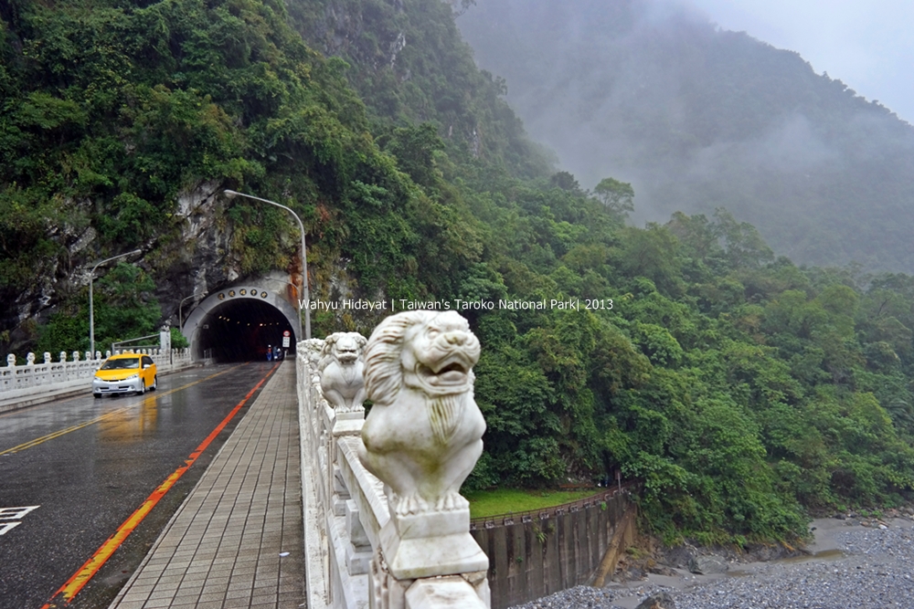
Shakadang Trail
Shakadang Trail is also known as “Mysterious Valley Trail” and was renamed to “Shakadang Trail” in 2001. This trail is built along the river cliff so travelers can easily observe both the rock folds and plant ecosystem beside in the Shakadang river valley.
The trail can be accessed from Bridge of 100 lions (all lions here have different poses!) and descending a set of stairs to the river’s edge.


Eternal Spring Shrine
The Changchun (Eternal Spring) Shrine commemorates the 226 personnel (military veterans) who died during the construction of the Central Cross-Island Highway (1956~1960). Spring water adjacent by the Eternal Spring Shine flows all year round, and the Highway Bureau named it after “Changchun Falls.” It is now scenic spot with special significance on the Central Cross-Island Highway.


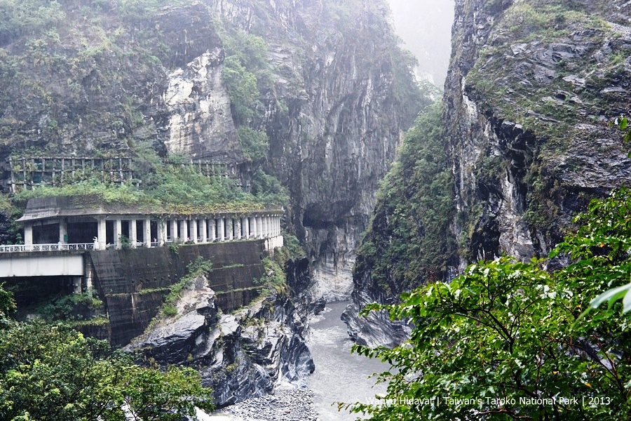
Swallow Grotto
Following the Central Cross-Island Highway, at Yanzikou (Swallow Grotto) the rock cliffs of the Liwu River gorge seem to reach to heaven while the river runs its swiftest and the distance between the gorge walls so narrow that they almost seem to touch each other.
Along the Yanzikou (Swallow Grotto) trail which runs about a half kilometer starting from the entrance to Swallow Grotto to the Jinheng Bridge, you can enjoy the sights of the Liwu River from nearly straight above the water, the potholes on the cliff faces, the springs sprinkled along the lower parts of the walls, as well as the famous rock formation “Chieftain’s profile rock”.


Cimu Bridge (Motherly Devotion Bridge)
Cimu Bridge(Motherly Devotion Bridge) is an H-Shape hanging bridge with marble stone lions on each end and with marble lotus stones on two sides. The rock beneath the bridge looks like a frog. The frog-like rock is composed of black layer of schist at the top and white marble at the bottom. A pavilion was built on this frog rock, becoming the crown on the frog. This was built by late President Chiang Jing-guo, in memory of his mother, during construction of the road. Cimu pavilion area is on the east side of the bridge, built by late President Chiang Kai-shek, in memory of his mother, Mrs. Wang.
This area where Laoxi River flowing from the marble valley into Liwu River is called the “Heliu” which stands for “merging flows.” The cliff has two different rocks layers.

Tianxiang and Xiangde Temple
Tianxiang – located almost at the center of the national park – is a large river terrace recreational area in Taroko National Park. Dasha River and Taci Jili River converge at Tianxiang to become Liwu River. Here we can see a tall White Robed Guanyin Statue, the 7-story high Tian Feng Pagoda, Giant Statute of the Bodhisattva, Xiangde Temple, Daxiong Baodian temple.


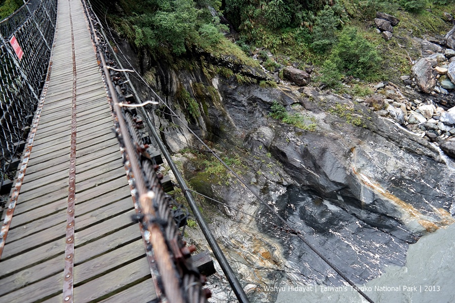
Heliu Suspension Bridge

Tunnel of Nine Turns
This is the most magnificent part of Taroko Gorge, where the sheer cliffs face each other. During the exploration stage, it is the especially difficult and dangerous part to explore. When the wind comes from the broad river valley to the narrow valley it is forced upwards when it hits the cliff face.
The Jiuqudong tunnel was constructed 1996, so that the visitors can view the rock folds, joints and faults of the marble cliffs. The two cliffs are so close to each other, and it looks like they are joining to each other if seen from afar. This section has the reputation of “Nine Turns of the Coiled Dragon”. The distance between the cliffs is only around 10-meters wide. In the small gap in the rocks, the narrow Kelan River’s rush by, forming a “Fish leaping across the dragon gate” scenery. The trail is a must-see point and one should stop by and enjoy the spectacular scenery that has been formed by tens of thousands of years of river erosion.

Qingshui Cliff
Situated between Heren and Chongde on the Su-Hua Highway, Qingshui Cliff is a big formed by Chongde, Qingshui and Heping mountain coastal cliffs. Creating a magnificent scene, it stretches more than 21km and rises vertically from the Pacific Ocean, with an average height of over 800m. This section of cliff is composed of gneiss and marble. It has risen straight up on the eastern coast of Taiwan for thousands of years. The route along the Qingshui Cliff is the only coastal road in Taroko National Park. The site of the Qingshui Cliff was designated in 1953 by the Taiwan government as one of the island’s “Eight Wonders.”
Among these cliffs, the east-south cliff of Mt. Qingshui is the steepest. The cliff facing the sea is 5km long and is very spectacular. Driving a car between cliff and the boundless ocean it almost feels like you are flying. The enormous cliff above combined with the boundless ocean below, reminding us of the hardships faced by the workers who built the road

Note:
1. Many, if not all, of the notes above is taken from Taroko National Park official website: http://www.taroko.gov.tw/English/?mm=5&sm=1&page=1#up. Thanks!
2. A 6-hour taxi hire costs us NTD2700 (appr. QAR330).
3. Hualien can be reached by plane (a 30-min flight from Shongshan Airport, Taipei), train (2 hours to 4 hours – we took both ends 🙂 ) or by car or bus.
4. Train costs us NTD340 (4-hour CK Express Train; many stops and slow) and NTD440 (2hour 5 min Taroko Express Train – few stops and fast)
5. Hotel: Les Champs NTD3600 nett including tax, services, and breakfast for two.
6. Check weather forecast before going and check Taroko National Park website to know which trails and roads are open/closed.

